
China Spreads Weather Modification Program Across Half The Country
China’s State Council announced plans to develop and expand its experimental weather modification program over the next five years to cover over 2.1 million square miles (5.5 million square kilometers). That’s an area over 1.5 times the size of India. All of it will be open to artificial rainfall (snowfall) while a smaller region of about 224,000 square miles (580,000 square kilometers) to hail suppression. The country aims to have weather modification reach an advanced worldwide level in terms of technologies, operation, and services by 2035.
The statement says:
The statement concludes by saying that the program will help with agricultural production, disaster relief, emergency responses to grassland and forest fires, droughts, and unusually high temperatures.

Weather modification is nothing new. The concept of cloud seeding – a way to artificially induce rainfall – has been around for decades, and China has been experimenting with it for several years already. The method involves misting clouds with silver iodide, which condenses around the drops of super-cooled water that are not growing efficiently enough to become raindrops. This causes the particles to become heavier, grow into a raindrop or snowflake, and fall as precipitation.


Chinese scientists are also working on a $19 million project called Tianhe (meaning Sky River) – the world’s largest and most ambitious artificial rain experiment yet. It involves using satellites and rockets to divert excess water vapor above the Yangtze river basin towards the country’s drier parts.
China adopts even more ambitious geo-engineering projects. For example, the country turns to seeding the atmosphere with reflective particles to reduce temperatures. While nobody knows of the consequences that could happen when the technique is employed. It could have significant unforeseen dangerous consequences.
Dhanasree Jayaram, a climate expert at the Manipal Academy of Higher Education in Karnataka, India, said:
This could be a massive global hazard that neighboring countries have speculated that weather modification could be used to steal rain or as a war tool, giving troops an advantage over their opponent. It’s been left an unchallenged practice especially by the UN, and WEF that’s for sure.
China Geo-engineering Corporation


#1 China Covering Tibet in Thousands of Cloud Seeding Generators!
China is planning on deploying thousands of silver iodide burning cloud seeding generators to generate snow on the Tibetan plateau in an attempt to alleviate water shortages. The massive scale of these experimental devices is troubling enough, but the ETC Group warned that these devices could easily be converted for geoengineering purposes:
This year we’ve been tracking a few high-profile geoengineering experiments in Arizona, Alaska, California, and Chile. Another massive project recently came to light on the Tibetan plateau: new research exposes what might be the largest geoengineering project to date, a weather modification project in the Himalayas, which is also part of an alarming pattern of dispossession of the Indigenous inhabitants. While a weather modification project at this scale is alarming enough the infrastructure used could easily transfer over to stratospheric aerosol injection.
Source: ETC Group Email
References: [1-4]


")
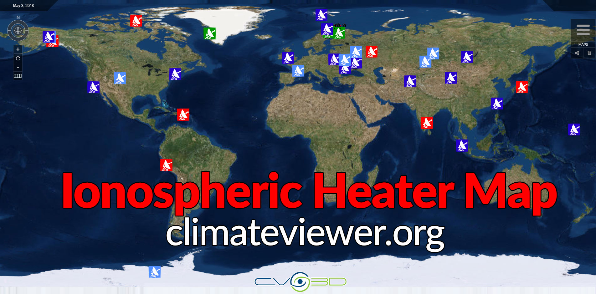
#2 China and Russia Work Together On Ionospheric Heating Experiment
China and Russia recently conducted a joint ionospheric modification experiment using the Sura Ionospheric Heater and a Chinese satellite to measure the ionospheric changes. This experiment is very similar to those conducted using the HAARP Ionospheric Research Instrument (IRI) in Gakona, Alaska and the DEMETER Satellite.
A total of five experiments were carried out in June. One, on June 7, caused physical disturbance over an area as large as 126,000 sq km (49,000 square miles), or about half the size of Britain.
The modified zone, looming more than 500km (310 miles) high over Vasilsursk, a small Russian town in eastern Europe, experienced an electric spike with 10 times more negatively charged subatomic particles than surrounding regions.
In another experiment on June 12, the temperature of thin, ionized gas in high altitude increased more than 100 degrees Celsius (212 degrees Fahrenheit) because of the particle flux.
The particles, or electrons, were pumped into the sky by Sura, an atmospheric heating facility in Vasilsursk built by the former Soviet Union’s military during the cold war.
The militaries have been in a race to control the ionosphere for decades.
The Sura base in Vasilsursk is believed to be the world’s first large-scale facility built for the purpose. Up and running in 1981, it enabled Soviet scientists to manipulate the sky as an instrument for military operations, such as submarine communication.


High-energy microwaves can pluck the electromagnetic field in ionosphere like fingers playing a harp. This can produce very low-frequency radio signals that can penetrate the ground or water – sometimes to depths of more than 100 meters (328 feet) in the ocean, which made it a possible communication method for submarines.
SOURCE: Chen, Stephen. "China and Russia band together on controversial heating experiments to modify the atmosphere." South China Morning Post (2018)
In June 2018, for the first time, the SURA heating facility in Russia , together with the in-orbit China Seismo-Electromagnetic Satellite (CSES), carried out a series of experiments in emitting high frequency (HF) O-mode radio waves to disturb the ionosphere. This paper reports data from those experiments, collected onboard CSES, including electric field, in-situ plasma parameters, and energetic particle flux. Five cases are analyzed, two cases in local daytime and three in local nighttime. We find that the pumping wave frequencies f0 in local daytime were close to the critical frequency of the F2 layer foF2, but no pumping waves were detected by the electric field detector (EFD) on CSES even when the emitted power reached 90 MW, and no obvious plasma disturbances were observed from CSES in those two daytime cases. But on June 16, there existed a spread F phenomena when f0 was lower than foF2 at that local daytime period. During the three cases in local nighttime, the pumping waves were clearly distinguished in the HF-band electric field at the emitted frequency with the emitted power only 30 MW; the power spectrum density of the electric field was larger by an order of magnitude than the normal background, with the propagating radius exceeding 200 km. Due to the small foF2 over SURA in June at that local nighttime period,f0 in these three cases were significantly higher than foF2, all belonging to under-dense heating conditions. As for the plasma parameters, only an increase of about 100 K in ion temperature was observed on June 12; in the other two cases (with one orbit without plasma data on June 17), no obvious plasma disturbances were found. This first joint SURA-CSES experiment illustrates that the present orbit of CSES can cross quite close to the SURA facility, which can insure an effective heating time from SURA so that CSES can observe the perturbations at the topside ionosphere excited by SURA in the near region. The detection of plasma disturbances on June 12 with under-dense heating mode in local nighttime provides evidence for likely success of future related experiments between CSES and SURA, or with other HF facilities.
SOURCE: Zhang, XueMin, et al. "The first joint experimental results between SURA and CSES." Earth and Planetary Physics 2.6 (2018): 527-537.
References: [5-6]

")
#3 China building their own Ionospheric Heater!
It seems that the joint Russia-China ionospheric heating experiments mentioned above are in preparation for China’s own brand-new heater, or incoherent scatter radar (ISR) dubbed the The Sanya High-powered Incoherent Scatter Radar.
The South China Morning Post has learned that Beijing is ready to start work building a powerful machine in Sanya, a resort on the island province of Hainan.
The device, known as a High-powered Incoherent Scatter Radar, would be capable of influencing the ebb and flow of subatomic particles as far away as Singapore, a distance of over 2,000km (1,200 miles).
This facility would be the most powerful radar in the South China Sea and – regardless of whether it can be used to generate extreme climate events – would have multiple military uses, including improving China’s submarine warfare capabilities and disrupting other countries’ communications networks by creating an atmospheric “black hole”.
The Sanya programme was officially launched in 2015 with a kick-starting fund of nearly 100 million yuan (US$15.7 million) from the central government. The goal was to develop and build the “world’s most advanced incoherent scatter radar”, according to information on the academy’s website.
Zhao declined to comment on the facility’s military applications.
“It is too early to talk about what the technology can do. There will be lots of technical challenges and engineering hurdles we may face and have to overcome,” he said.
“The main purpose of this programme is to study the ionosphere over the South China Sea. Currently there is no such device in this region. The data collected by our instrument will fill gaps in our knowledge.”
There were other similar facilities under construction in China with a power output “much larger than ours”, Zhao said.
SOURCE: Chen, Stephen. "Could this new Chinese radar system really be used to play God with the weather?." South China Morning Post (2018)
References: [7]

 Worldwide")
#4 China’s Tianhe Project (Sky River) Will Divert Atmospheric Rivers Using Undisclosed Technology
I have covered several companies such as Aquiess, Miles Research, and Climate Control Global Trading LLC which claim to be able to divert atmospheric rivers (tropospheric rivers, or rivers in the sky). Now China is claiming to manage their water resources using this new technology.
"Once the Tianhe Project is completed, it will be possible to transfer water in the air via an ‘air corridor.' [The corridor] will be formed as part of the South-to-North Water Diversion project," said Wang Guangqian, an academician with the Chinese Academy of Sciences (CAS) and president of Qinghai University. Wang introduced his proposal at a meeting on Sept. 9, which aimed to jumpstart the novel project.
According to the project's description, the atmospheric boundary layer and the troposphere form a passage through which water vapor can be transported in a stable and orderly way. The passage can be regarded as "tianhe" (literally, a river in the sky). The proposed undertaking has therefore been named "Tianhe Project."
"We monitor the content and migration routes of water vapor, and then we conduct interference in certain regions to solve water shortages in northern China," Wang explained.
SOURCE: "Tianhe Project proposes ‘air corridor’ to advance cross-regional water diversion." People's Daily Online, China (2018)
CHINA is launching a bizarre bid to control Earth’s weather so it can shift rain clouds thousands of miles from its soaking south to its parched north.
Six satellites will form a ring to spot water-laden clouds and create an atmospheric corridor to allow them to move to the arid regions, state media said.
SOURCE: Knox, Patrick. "RAIN MAKERS China ‘will move clouds and make it rain in different places using satellites’ in terrifying weather control plan" The Sun, UK (2018)
China has put on display a satellite model of its Tianhe project, which aims to move water vapor in the sky from the damp west part of the country to the arid northern area of Sanjiangyuan in Qinghai province.
Tianhe, literally meaning "sky river" in English, involves the use of six satellites, and is on display at the 12th China International Aviation and Aerospace Exhibition in Zhuhai, in south China's Guangdong province.
The first two Tianhe satellites will be sent into space in 2020, according to, Liu Weiliang from the Shanghai Academy of Spaceflight Technology, which is spearheading the idea. Set for operation in 2022, the satellites will provide technical support for the transportation of water vapor along the air corridor.
A team from the Chinese Academy of Sciences, led by academic Wang Guangqian, discovered that the atmospheric boundary layer and the troposphere form a stable passage through which water vapor moves from the western Indian Ocean, eastern Indian Ocean, Yunnan-Guizhou Plateau and Central Asia.
The Tianhe-1 satellites and the system will be the country's first dedicated constellation of satellites that detect water resources in the air.
Tianhe-1 is a low-orbit satellite installed with a microwave hygrometer, precipitation-measuring radar and cloud water detector to create three-dimensional information on water resources over the area.
SOURCE: Yushuo, Zhang. "China Unveils Satellite Plans for Diverting Water Through the Sky." Yicai Global, China (2018)
References: [8-14]


#5 China’s new Extremely Low Frequency (ELF) Transmitter is FIVE times the size of New York City
China has built a giant experimental radio antenna on a piece of land almost five times the size of New York City, according to researchers involved in the highly controversial project.
The Wireless Electromagnetic Method (WEM) project took 13 years to build but researchers said that it was finally ready to emit extremely low frequency radio waves, also known as ELF waves. Those waves have been linked to cancer by the World Health Organisation-affiliated International Agency for Research on Cancer.
Although the project has civilian applications – officially it will be used for earthquake and mineral detection and forms part of China’s 11th five-year plan – it could also play a crucial role in military communications.
Scientists said that its transmissions could be picked up by a submarine lurking hundreds of metres under the sea, thus reducing the vessel’s risk of having to resurface to receive transmissions.
The project follows the construction of China’s first military-grade Super Low Frequency transmission station in 2009.
The next year, a Chinese nuclear submarine successfully communicated with the station from deep water – making China the third country in the world to have established such a submarine communication system, after the United States and Russia.
But the Chinese navy is eager to expand its capacity and has been pouring resources into the more advanced ELF radio technology, which allows submarines to communicate with the command centre from a greater depth and is harder to disrupt.
The Chinese government, however, has played down the importance of the facility, which occupies some 3,700 sq km (1,400 square miles) of land, in information released to the public.
Apart from the need to protect an important strategic asset, some researchers said that the secrecy was to avoid causing public alarm.
The antenna would emit ELF signals with a frequency of between 0.1 to 300 hertz, the researchers said.
The exact site of the facility has not been disclosed, but information available in Chinese research journals suggests it is in the Huazhong region, an area in central China that includes Hubei, Henan and Hunan provinces and is home to more than 230 million people – greater than the population of Brazil.
Project WEM’s main surface structure is a pair of high voltage power supply lines stretching from north to south, east to west on steel lattice towers, which form a cross that is 60km (37 miles) wide and 80km to 100km (50 to 62 miles) long.
At the end of each power line, thick copper wire goes underground through a deep borehole. Two power stations generate strong currents and electrify the ground in slow, repeating pulses, turning the earth underfoot into an active source of electromagnetic radiation.
The radio pulses not only pass through the atmosphere, but travel through the Earth’s crust as well, with a range of up to 3,500km (almost 2,200 miles), according to the project scientists.
A sensitive receiver within that range, which is roughly the distance between China and Singapore or Guam, would be able to pick up these signals.
The closer to the power source, the stronger the pulses.
The radar will be difficult for spy satellites to detect because it will appear no different to an ordinary power grid, although a radar expert said it might be possible to detect its emissions and use those to determine the location.
The inland location of the new facility would also make it harder for an enemy to attack, compared with a facility located on the coast.
Chen Xiaobin, a researcher with the Institute of Geology, China Earthquake Administration, who has been working on the project, said he did not know its exact location because that information needed a high level of security clearance.
“This facility will have important military uses if a war breaks out … Though I am involved in the project, I have no idea where it is. It should be up and running by now,” he said.
Lu Jianxun, the chief scientist on the project, also leads a key communication programme at the PLA Naval Command, according to information on Chinese government websites.
The construction work was led by 724 Research Institute under the China Shipbuilding Industry Corporation, which is a major supplier of communications and electronic warfare equipment to the Chinese navy.
Hu Wenmin, president of the corporation, visited the emission site in May last year, according to a statement on the state-owned company’s website.
Hu “expressed his appreciation for the construction of the WEM project and put forward opinions and requirements for the follow-up development of the project and the technical application in related fields”, the statement said.
But the project has caused concern among some academics, who worry about the possible impact on public health.
The International Agency for Research on Cancer, part of the World Health Organisation, has previously warned that ELF waves are “possibly carcinogenic to humans”.
Numerous epidemiological and experimental studies conducted by researchers around the world have linked long-term ELF exposure to an increased risk of childhood leukaemia.
In a 500-page report constantly updated since 2007, the WHO has documented a large number of academic investigations linking ELF radiation to a range of illnesses including delusions, sleep deprivation, stress, depression, breast and brain tumours, miscarriages and suicide.
Though many results remain inconclusive, the WHO said the implementation of precautionary procedures to reduce exposure was “reasonable and warranted”.
Chen declined to comment on the impact the facility would have on residents’ health.
But some researchers said that China’s environmental authorities have concerns about the project.
The Ministry of Ecology and Environment, for instance, asked for a comprehensive review on its environmental impact – a request that has not been granted.
“The money came from civilian budgets, but the military has intervened and muted the ministry’s complaint,” said a Beijing-based researcher, who asked not to be named due to the sensitivity of the issue.
The ministry did not respond to a request for comment.
According to one calculation by the Chinese navy, a person standing on the emission site would be subject to ELF radiation no greater than 10 watts, enough to power up several LED light bulbs.
But Qiao Fengshou, a researcher with the navy’s Ship Communication Research Institute in Wuhan, who made the estimate, said there was nothing to worry about.
According to China’s safety standards, only radiation greater than 300 watts is considered harmful, so the project will cause “no harm to staff and residents in surrounding areas, it is not necessary to build extra facilities for the purpose of health protection”, Qiao wrote in an article in the Chinese-language research journal Ship Science and Technology in 2016.
Qiao also said that the project would be given an “exemption from supervision” by the environmental authorities.
Xi Jilou, a researcher with the Institute of Earthquake Forecasting who was not directly involved in the project but informed about it, said that relevant authorities had recently conducted final checks on the emission site and concluded it was ready for operation.
“There should be some devices monitoring the environment on the site for the protection of public health,” Xi said.
“China is not the first country doing this. Other countries conducted similar projects long ago.”
In 1968, the US Navy proposed Project Sanguine, a giant ELF antenna that would have covered two-fifths of the state of Wisconsin to enable undersea communications with submarines.
The project was terminated due to massive protest by residents.
The US Navy built a smaller transmitter, the Wisconsin Test Facility, with two 45km power lines in the Clam Lake area, a place with a low population density. The station emitted ELF waves at 76 hertz and was decommissioned over a decade ago.
In the 1980s the Soviet Union constructed Zevs, a considerably more powerful facility on the Kola Peninsula inside the Arctic Circle.
The Zevs antenna was powered by two 60km electric lines and had a main frequency turned at 82 hertz. The radio waves it produced were believed powerful enough to reach Russian nuclear submarines hidden deep under the Arctic ice cap.
Russia has since provided technical support to China as it started building its own systems, which may include other ELF stations in coastal areas.
According to the WHO, an ELF field can affect human nerve fibres and stimulate synaptic transmissions in neural networks.
It can also affect retina cells, generating a sporadic flash of light in people’s eyes.
Animals can use low frequency signals to detect threats or changes in surrounding environments, an ability critical for survival in nature, according to some biologists, and experiments suggest that ELF radiation could also have an effect on cattle.
Huang Zhiwei, a professor with the department of electrical engineering at Nanhua University in Hengyang, Hunan, said the ELF radio was unlikely to cause acute damage to the human body due to its enormous wavelength, which could stretch over thousands of kilometres, but it might interfere with the sensory organs.
“If the frequency caused a resonance with our sensors it could be a nightmare,” said Huang, who was concerned because he and his family live in the region.
Some previous studies had shown that wounds healed more slowly when exposed to ELF radio waves several times a day, Huang added.
Huang, who has taken part in numerous military research projects, said the environmental impact of defence-related facilities was usually not scrutinised as much as civilian projects.
“The matter must be handled with extreme caution, or it can easily lead to public panic,” he said.
Huang said the authorities in charge of the WEM project should recruit a large number of volunteers for comparison studies.
The sample size must be sufficiently large because of variations in environment and timing or the individuals involved could produce different results.
“Some people are more sensitive. They can see or hear things other people can’t. They may be more vulnerable to the impact,” Huang said.
Researchers also said that the facility would also have a peacetime application and be used to detect mineral and oil deposits.
Ground stations with special equipment can pick up signals to survey underground structures to an unprecedented depth.
The ELF waves will also be able to detect rock deformations, which could help in studying precursors for major earthquakes.
In 2013, China’s state media reported that the PLA Navy had completed the development of the world’s most powerful and sensitivity low-frequency communication system for nuclear submarines.
The reports described the technology as having the world’s largest communication distance and deepest communication depth, according to the official report.
The US Navy shut down its Wisconsin transmitter in 2004, saying it no longer needed to rely on ELF radio.
Instead, US nuclear submarine fleets use very low frequency or VLF radio waves, with a frequency ranging from 3 to 30 kilohertz, for long-distance communication.
The VLF radio waves can carry more information than ELF signals because of this higher frequency, and can penetrate seawater to a depth of up to 40 metres (130 feet).
References: [15-17]
 project ELF transmitter")


Weather Modification History Interactive Timeline (1800 - Present)
https://weathermodificationhistory.com/interactive-timeline/
No comments:
Post a Comment
Comments always welcome!