BC Gold & Jade
Lillooet, BC, Canada


Founded as Mile 0 on the wagon road leading to the Cariboo and Barkerville gold fields, Lillooet was a child of the Gold Rush, like so many Cariboo towns. Serving as a terminus for boat routes across Harrison and Anderson Lakes, at the start of the first Cariboo Road, the town had swelled to almost 15,000 residents within twenty years of its founding.
Originally known as Cayoosh Flat because of the good grazing that cayuses (Indian Ponies) found there, the town was renamed in the mid 1860s in honour of the Leelwat First Nations people who live in the region.
Many towns along the Cariboo Highway are helpfully referred to by the distance north along the Gold Rush Trail from Lillooet. The distance north to 100 Mile House is therefore not too challenging to determine.
Rockhounds and history buffs will find Lillooet to be an academic treasure. Lillooet has one of the most pleasant climates in Canada, a combination of the sunny skies of the BC interior with the moderating influences of the coast.
Lillooet also wins First Prize for the most unusual golf course in B.C. (maybe the world?) An enterprising local sheep farmer here has converted the pastures of his scenic farm into an 18-hole golf course. Watch where you step, as the wooly residents are likely to have added their own unique addition to the list of hazards and obstacles.
Population: 2,779
Location: Lillooet is located at the junction of Highway 12 and Highway 99, 106 miles (180 km) north of Hope and 213 miles (340 km) northeast of Vancouver.
The Lillooet Museum has many displays detailing the communities colourful and fascinating past. Lillooet retains vestiges of its past in the old Anglican Church on Main Street, and its pioneer cemetery. Main Street, built wide enough for the old traders to turn their 20-oxen carts, is said to point exactly due north. Lillooet is steeped in the memories of yesteryear. All around this area are ghost towns, railways, and old mines. History buffs can tourMiyazaki Heritage House, built by Caspar Phair, one of Lillooet’s first settlers.
The old Salt Box frame house, once ringed with porches, is the former home of the Bridge River – Lillooet News. The paper was established in 1934 by MLA George Murray, who founded the paper as a campaign promise to the Lillooet residents of the day. It was made famous by his wife, Margaret, who gained fame as the inimitable Ma Murray. The building was originally built as a rooming house for PGE construction crews working on the railway. It now accommodates private apartments.
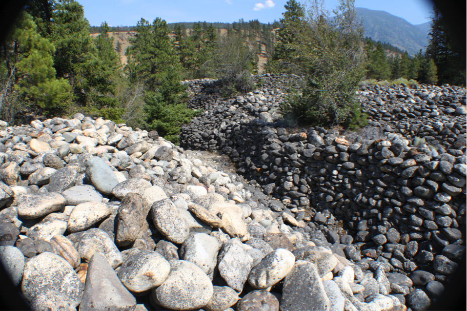
The Chinese Rock Piles provide a reminder of the plunder for gold and Jade by Chinese people before the turn of the nineteenth century. They washed the sand and gravel for the elusive yellow metal, and piled the washed rocks in long rows, some 12 feet high in some places. The rocks are found on both sides of the Fraser River, with the best remaining examples found below Hangman’s Tree Park. Others are just downstream from the old suspension bridge, and on the east side of the Fraser River.
Hangman’s Tree, located on the benchland overlooking Lillooet, was allegedly used as a gallows during the 1880s gold rush by the hanging judge, Sir Mathew Baillie Begbie. There is a record that two thieves were hanged and buried beneath the tree, and legend has it that eight lawbreakers in all swung from the tree. The bough which actually accommodated the noose has since rotted off, but the gnarled old pine remains. If you don’t think the story is worthy of the walk, the view certainly is.
Bridge of 23 Camels: Innovative Lillooet resident John Callbreath experimented with camels as pack animals, hoping to make an improvement over the oft-stubborn mule. In 1862 he bought 23 camels in San Fransisco for $300, and shipped them to Lillooet to work in the Gold Rush. While efficient they were, their tender feet, bad tempers and foul odour led to the scheme’s demise. While the camels were a dismal failure, they nonetheless left a strong impression on townsfolk, as evidenced by their memorial, Lillooet’s Bridge of 23 Camels.
Since the construction of the Bridge of the 23 Camels, the bridge built by Royal Engineers in 1913 has been known by local residents as The Old Bridge. The span is a suspension bridge of steel cables and wood, with ‘dead men’ embedded in the rock banks of the Fraser River. This bridge replaced a truss bridge, which in turn had replaced a winch ferry built in 1860 that was powered by the river current.
The Mile O Cairn was erected in 1939, marking mile zero of the old Cariboo Road in the early stage coach days. All road houses and stopping places from this point on to Barkerville were known by their mileage from Lillooet – 70 Mile House, 100 Mile House, and so on. In 1858, Governor James Douglas ordered the construction of a trail from Fort Douglas on Harrison Lake to Lillooet. The Royal Engineers supervised the construction, and miners with picks and shovels were contracted to build the road for the sum of five English pounds each, which they received upon their arrival in Lillooet by land and portage. Sixteen thousand gold seekers were outfitted in Lillooet by 1863, when the alternative Fraser Canyon route from Yale finally reached Lytton. While the mile zero cairn is located in the centre of Lillooet, the actual Mile O was across the Fraser River in East Lillooet.
Hiking: Hiking trails are everywhere, suitable for everyone from beginners to experts. From jagged gorges bordered by rugged peaks to gentle meadows with meandering creeks…the Lillooet area has it all.
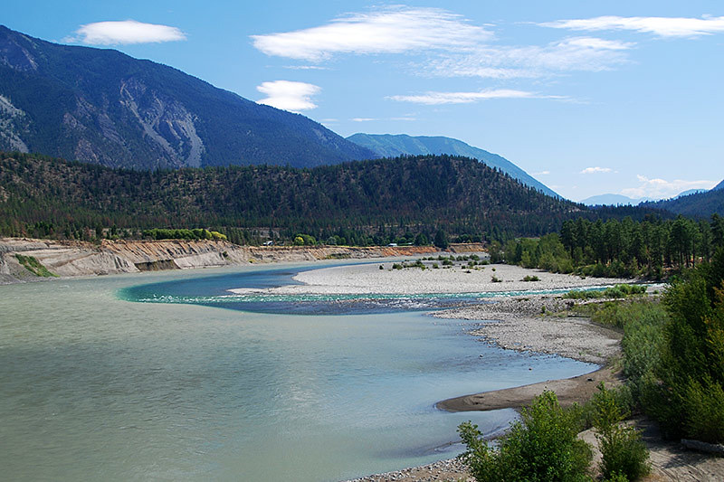
Jet boating on the mighty Fraser River is an exhilarating experience. Tours are offered between Lillooet and Lytton. As you travel downriver, tour guides interpret the fascinating history of the Fraser River, describing its importance to local First Nations cultures and pointing out evidence of the thousands of gold-fevered prospectors who passed this way in the 1800s.
Fishing: Whether you’re angling for monster sturgeon, king size chinook salmon, feisty steelhead, huge dolly varden, or plump rainbow trout, the Lillooet and Lytton region has them all.
Golf: The rather unique Sheep Pasture Golf Course is located on a working sheep ranch on Texas Creek Road, a few kilometers down the Fraser River from Lillooet. The 9-hole, par-35 course (2,722 yards) is played while surrounded by grazing sheep. Tournaments are held in summer, including the Bo Peep, the Sheep Pasture Open, and the First Nations Tournament. Golf Vacations in British Columbia.
Rockhounds in search of Jade, and other semi-precious stones, are attracted to the productive Lillooet area.
Wildlife: Mountain Goats, big horn sheep, cougar, and black bear range in the mountains surrounding Tyaughton Lake, which rise to about 3,000 metres.
Nestled in a canyon between Lillooet and Cache Creek is Pavillion Lake, which contains mysterious underwater formations of coral-like structures, some of which are up to four metres high, up to 11,000 years old, and covered in mats of microscopic, sunlight-loving microbes. Teams of scientists from NASA, Simon Fraser University and Portland State University believe that the massive structures have been created by microbes and are not found anywhere else in the world. The Underwater Council of BC has applied to the province for their protection.
The Pemberton Wetlands Wildlife Management Area (753 hectares) encompasses a number of freshwater wetlands in the vicinity of the Upper Lillooet River and Green River in Pemberton. The wetlands provide habitat for salmon and other fish species, waterfowl, songbirds, moose, beaver, otter, and black bear.
The Stein Valley is one of the last untouched watersheds in the southwestern part of the province. Stein Valley Nlaka’pamux Heritage Park offers a very rewarding (if demanding) 75-km hike that runs the full length of the valley, suitable for very fit, experienced hikers who are prepared to be totally self-sufficient. Once you have reached Stein Lake, you are at least two days away from any assistance. There are other hikes available here, which vary in difficulty and length. The main trailhead into the park is located north of Lytton, near the mouth of the Stein River’s confluence with the Fraser River.
First Nations Tours: Visitors can tour the Bridge River Fishing Grounds, the past and current fishing area of the St’át’imc People, and learn about the traditional wind-dried method of preserving salmon still used by its people today. Tour an extensive archaeological village site that contains over 80 identified pit houses (s7ístken), the traditional winter homes of the St’át’imc people. Partake in a Salmon BBQ, complete with salmon, rice, salad, and bannock. Dessert is a traditional dish of whipped berries (sxúsum). Xwísten Experience Tours is located by the Bridge River bridge 6 kilometers north of Lillooet.
To the southwest of Lillooet, on the Sea to Sky Highway, lies the rustic village of Pemberton and the First Nations community of Mount Currie. Visitors remark upon the beauty of this stretch of peaceful farmland sheltered all around by the majestic snow-capped Coastal Mountains.
North of Lillooet is the Cariboo town of Clinton, once a busy junction on the wagon road leading to the Cariboo and Barkerville gold fields. An historical cairn in Clinton marks the junction of two routes to the Cariboo gold mines; The original 1859 Cariboo Trail from Lillooet, and the Cariboo Road through the Fraser Canyon.
Circle Tour: See the best of the area on a driving Circle Tour. Head north out of Vancouver for a scenic tour of theSunshine Coast and Vancouver Island, or stay on the intensely scenic Sea to Sky Highway, passing through the magical winter resort town of Whistler and looping through the Coast Mountains. To explore the rural farmlands and forests of the fertile Fraser Valley, travel outbound on the scenic route north of the historic Fraser River, returning westwards along the Trans Canada Highway 1 to Vancouver.
Circle Tours in British Columbia.
Circle Tours in British Columbia.
No comments:
Post a Comment
Comments always welcome!