As shocking as it may sound
Is Vancouver prepared for an earthquake?
As shocking as it may sound, the Cascadia Subduction Zone earthquake isn’t even Vancouver’s largest seismic threat. Local emergency crews are now preparing for something even more catastrophic just below the surface
October 29, 2015
This article was originally published in the November 2015 issue of Vancouver magazine.
Unless you took a summer vacation from social media (or even traditional media), you probably spent a few conversations discussing the New Yorker story on the impending demise of the West Coast courtesy of The Big One, the coming 9-point-something-magnitude megathrust Cascadia subduction zone earthquake geologically identical to the one that devastated Japan in 2011. Our Kraken will rise from deep under the ocean, 75 kilometres west of Vancouver Island, where the oceanic Juan de Fuca plate wedges under—or subducts—eastward, bending and stressing the North American plate, on which Vancouver (and Victoria, Seattle, Portland, and millions of residents) sit, buckling it up and east. When our plate can’t take any more bending, it will snap back westward, producing one of the planet’s most powerful quakes ever recorded—much stronger in magnitude than anything the mere San Andreas fault is capable of. The last earthquake like this in B.C. was in 1700. It wiped out First Nations villages on the west coast of Vancouver Island, Washington state, and Oregon and generated a tsunami that hit Japan the next day.
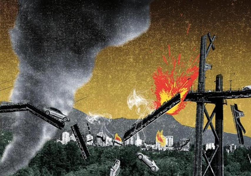
The modern version in Vancouver will feel like a giant camel ride—up, down, up, down—as a series of enormous seismic waves moves through the ground. That’s how John Clague, a Simon Fraser University earth sciences professor and one of B.C.’s pre-eminent earthquake specialists, envisions it. “It’s not what most people think of as an earthquake,” says Clague, sitting on bedrock at his mountain office high above Burrard Inlet. “It’s a rolling type of ground motion.” No chasms will open in the earth. Buildings won’t split apart. Instead, Vancouver’s towers will begin to oscillate as though they are masts on boats at sea. Some may smash into each other. Anything that is long—a bridge, a road, a pier—will be especially stressed as the wave moves along its length, with one part rising while another part lowers.
All the land in the Lower Mainland that is essentially mud or gravel (post-glacial fill, in scientific terms) will start to quiver, to liquefy. That won’t be just in Richmond, as many people think. All of Delta, except for the bits on bluffs in the north and in Tsawwassen, will experience the same, as will the land that edges Vancouver’s False Creek and the mud flats along the shores of UBC, North Vancouver, Pitt Meadows, and Port Coquitlam.
The Cascadia subduction zone earthquake scenario described in blood-curdling detail by theNew Yorker (“Everything west of Interstate 5 will be toast”) prompted public panic when it overlaid nature’s blind destruction on today’s metropolitan grid: coastal communities obliterated by tsunamis, cities without power for weeks or months, and 40,000 dead or injured. Geologists and emergency-management personnel took to Reddit to try to calm people down soon after the story was published.
That Cascadia quake is also the earthquake scenario that the Insurance Bureau of Canada chose two years ago to assess what the impact would be in B.C. The bureau’s language was somewhat more restrained than that of the New Yorker’s, but its conclusion in the 344-page report was not. Although the report is dotted with what seem like reassuring phrases—many low-rise buildings will experience “light” or “moderate” damage; “most of the major roadways in and around Vancouver may experience only slight damage”—the total picture is catastrophic, as it describes in minute detail what would happen to various buildings, roads, and bridges when the earthquake hits on a sunny afternoon in July. About $60 billion in damage, mostly from the shaking, but also from fires, water damage from the low-grade tsunami, liquefaction, and landslides. The report, which is narrowly focused on property damage, didn’t try to estimate deaths, but presumably there would be many.
So the Cascadia Big One is bad. But it’s not the most catastrophic earthquake that will hit this city. In a plan made public in late July, Emergency Management B.C. (EMBC), using modelling from the National Resources Council, based its disaster scenario not on the megathrust Cascadia possibility, but on something much closer: a shallow crustal 7.3-magnitude earthquake somewhere under the Strait of Georgia. That one, unlike like the Cascadia quake, will produce earth ripples coming from multiple directions, the full complement of different kinds of seismic wave forms. It will hit the city, says Clague, more like a bucking bull that is humping and twisting at the same time. Since the epicentre will be much closer to the city and also closer to the surface, there will be both high amplitude and high ground acceleration. Or, put another way: “That’s where you get the Hollywood scare-movie scenes. Buildings are getting torqued like they’re in a conga line. Roads will crack. The ground may open up, just like in the movies.” Clague’s biggest worry about the city? “Those West End high-rises. I’ve never really said that in public because I don’t want to alarm people.” But they, along with many in Gastown, are among the city’s oldest tall buildings, most built before B.C. started changing its building code to consider seismic protection in the 1970s.
This is how EMBC paints the picture, which is set on a rainy afternoon in January: “For many, the earthquake is heard before it is felt. The low, rumbling sound is similar to that of a freight train, immediately followed by 10 to 20 seconds of violent shaking that knocks people located closest to the epicentre from their feet. Taller buildings sway with the high-intensity shaking. Buildings on softer soils lose support through liquefaction. Landslides and rockfalls are generated in many areas, cutting off transportation routes. Several fires start throughout the impact area from damaged electrical power and gas lines. Some buildings collapse, many shift and crack, and others are destroyed by fire. Many of those who try to run outside suffer extreme injury or death from falling and flying objects and thousands are trapped or injured. Dust, smoke, and sirens fill the air.” Deaths? Estimated at 10,000.
Those two scenarios are part of an ever-increasing focus in B.C. on planning for an earthquake in almost block-by-block detail. Spurred by a series of disasters around the Pacific Ring of Fire, where Vancouver has a seat at the table; by B.C. auditor-general reports (1997 and 2014) warning that the province doesn’t have a coherent plan for an earthquake; by public anxiety over century-old brick schools; and by individual researchers or local politicians, the region is very gradually upping its game. The Massey Tunnel and all of the bridges except the Pattullo have been upgraded. In fact, disaster scenarios estimate they’ll stand, although the roads leading to them, often built on that liquefying fill, may not. Government buildings are being assessed and retrofitted or emptied. The east wing of Vancouver’s city hall, which was cleared out last year, is the most vivid example of that. St. Paul’s Hospital, which holds the unenviable position of Hospital Most Likely to Collapse During an Earthquake, is going to move to a new building by 2022. Delta just decided to move its emergency-response centre from city hall after coming to the realization, as Mayor Lois Jackson says, that it “may be in jeopardy,” to a control room planned for the Boundary Bay Airport. Schools are slowly —excruciatingly slowly—being upgraded or replaced.
The District of North Vancouver became the first of the region’s 21 municipalities to do a building-by-building assessment, producing a map and study in April showing exactly what would crumble and what would stand. (The District also used the 7.3-magnitude Strait of Georgia quake as its worst-case scenario.) Some things to ponder, for those working, living, or commuting through the district: the land around the north end of the Lions Gate Bridge and just to the east might move laterally as much as two feet during an earthquake. That area, plus the area around the Seymour River and Ironworkers Bridge, is projected to see 20 percent or more of its buildings completely destroyed and a death and casualty rate of between five and 10 percent of the population there. That “microzonation,” done through a special collaboration between the District, which provided the millions of bits of data, the National Research Council, and the American Federal Emergency Management Agency, is the kind of overview the whole region should have, say people like Clague and others.
In the meantime, while scientists are refining the picture of exactly what an earthquake disaster will look like, the people who will be responsible for pulling bodies out of the rubble, transporting the injured to hospital, putting out fires, and trying to make the city functional again are refining theirs.
At a giant, nondescript barn of a building smack in the middle of Surrey (on high, stable land), there’s a room lined with television screens and banks of computers at seven different stations. Between the two sets of screens, the half-dozen men working here track every bus, SkyTrain car, service vehicle, and social-media spike.
This is the control centre for TransLink, which, on this particular day, is still recovering from and pondering the lessons learned during Vancouver’s summer windstorm. It’s where the people monitoring the screens had to reroute buses and deal with power outages and trees on the track.
It turns out that this centre, along with other transit hubs throughout the region, along with the good ol’ buses, will be key components during an earthquake. When either of the catastrophic quakes hit, all the SkyTrain lines will be shut down immediately until structural engineers can check them. The same will happen with all bridges and tunnels. The power will likely be out in as many places as the windstorm hit this August. There will be fires and collapsed buildings everywhere. And, since large centres typically have only two days’ fuel supply, all vehicles that don’t have access to their own source will be unusable.
Since the region’s transit centres have their own generators, emergency food supplies, radio phones, and access to fuel that others won’t have during a disaster, they will remain functional even if power, gas stations, and stores are knocked out everywhere else. They also can be the place where emergency crews set up shop, since they have lots of precious empty land around them, usually used for storing buses.
As for the buses, they’ll turn into the region’s lifelines. “They can be used for emergency crews, for evacuations, for social services,” says John Oakley, the man in charge of emergency preparation for TransLink. “They’re a shelter. And they can be turned into mobile first-aid units.”
But as ready as everyone is getting, the region is still a long way from Japan-level preparedness. So people like Oakley have one last wish for how the earthquake scenario will unfold. It’s not about whether it’s the Cascadia earthquake or the Strait of Georgia earthquake, whether it’s in January or July. “My personal worst scenario is that it happens in the middle of the day, when children are in school and everyone is at work. If it happens in the middle of the night, half our problems are solved. We almost have two operations we plan for.”
No comments:
Post a Comment
Comments always welcome!