Qinghai Lake [Now A Rubbish Dump]
From Wikipedia, the free encyclopedia
| Qinghai Lake | |
|---|---|

From space (November 1994). North is to the left.
| |
| Location | Tibetan Plateau |
| Coordinates | 37°00′N 100°08′ECoordinates: 37°00′N 100°08′E |
| Type | Endorheic, saline lake |
| Surface area | 4,186 km2 (1,616 sq mi) (2004), 4,489 km2 (1,733 sq mi) (2007)[1] |
| References | [1] |
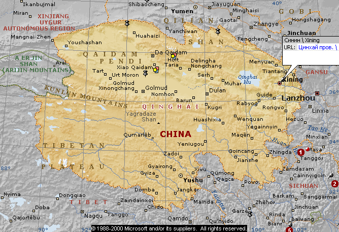
Qinghai Lake (Chinese: 青海湖), Kokonor (Mongolian : Хөх нуур) or Tsongon Po(Tibetan: མཚོ་སྔོན་པོ།) is the largest lake in the People's Republic of China. Located in Qinghaiprovince on an endorheic basin, Qinghai Lake is classified as a saline and alkaline lake. Qinghai Lake has a surface area of 4,317 square km; an average depth of 21m, and a maximum depth of 25.5m as measured in 2008.[2] Both the current Chinese name "Qinghai" and the older Mongolian name Kokonor translate to "Blue Lake" or "Teal Sea", are used in English. Qinghai Lake is located about 100 kilometres (62 mi) west of the provincial capital of Xining (Tib:Ziling ཟི་ལིང་།) at 3,205 m (10,515 feet) above sea level in adepression of the Tibetan plateau.[3] Twenty-three rivers and streams empty into Qinghai Lake, most of them seasonal. Five permanent streams provide 80% of total influx.[4]
The lake has fluctuated in size, shrinking over much of the 20th century, but has increased since 2004. Despite its salinity, it has an abundance of fish, such as the ediblenaked carp (Gymnocypris przewalskii, huángyú (湟鱼)).[5]Geography[edit]
| Qinghai Lake | |
 |
Qinghai Lake is sandwiched between Hainan and Haibei Tibetan Autonomous Prefectures in northeastern Qinghai. The lake is located at the crossroads of several bird migration routes across Asia. Many species use Qinghai as an intermediate stop during migration. As such, it is a focal point in global concerns of avian influenza (H5N1), as a major outbreak here could spread the virus across Europe and Asia, further increasing the chances of a pandemic. Minor outbreaks of H5N1 have already been identified at the lake. At the tip of the peninsula on the western side of the lake are the "Bird Islands" (Cormorant Island and Egg Island), which have been bird sanctuaries of the Qinghai Lake Natural Protection Zone since 1997. The lake often remains frozen for three months continuously in winter.[citation needed]
There is an island in the western part of the lake with a temple and a few hermitages called "Mahādeva, the Heart of the Lake" (mTsho snying Ma hā de wa) which historically was home to a Buddhist monastery.[6] No boat was used during summer, only when the lake froze over in winter could monks reach the mainland or pilgrims visit the temple—many of whom used to come from Tibetan areas and Mongolia. A nomad described the size of the island by saying that: "if in the morning a she-goat starts to browse the grass around it clockwise and its kid anti-clockwise, they will meet only in the night, which shows how big the island is."[7] It is also known as the place where Gushri Khan and other Khoshut Mongols migrated to during the 1620s.[8]
The lake is circumambulated by pilgrims mainly Tibetan Buddhist followers, especially every Horse Year of the twelve cycle years turn out to the great pilgrimage to the Tibetans. Przhevalsky estimated it would take about 8 days by horse or 15 walking to circumambulate the lake, but pilgrims report it takes about 18 days on horseback, and one took 23 days walking to complete the circuit.[9]


No comments:
Post a Comment
Comments always welcome!